The natural beauty of this 9.7 square mile island is what captures
immediate attention.
The view of Jamestown as you leave North Kingstown and head east is,
quite simply, gorgeous. From the top of the bridge, the viewer looks
north to the West Passage of Narragansett Bay, south towards Beavertail
and out to the ocean. Driving across the island, in a few minutes, the
Newport Bridge appears. The East Passage of Narragansett Bay is ahead,
with the sailing capital of Newport and its famed harbor just off to the
south.
Heading into town, you will come over a hill and look down to
Jamestown's harbor and its town center. The architecture, a New
England blend of predominantly shingle style cottages from grand to
simple, characterizes the charming village. A perfect grouping of
restaurants, shops, and marine-focused businesses give Jamestowners and
visitors an apt assortment to choose from, allowing us to have
everything we need without leaving the island. East Ferry is where our
Island Realty office is located, just next to the original ferry dock
where Conanicut Marina still operates a popular
summer water taxi.
The population of Jamestown is about 6,000 year round residents. In the
summer, the population grows to about 10,000 at its maximum.
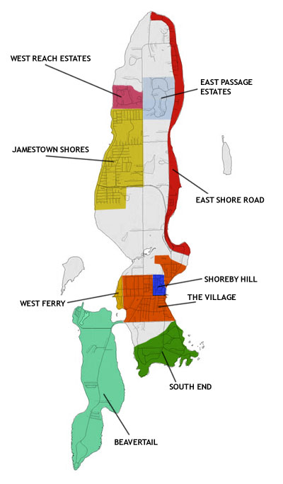
The south end of Jamestown has a rugged coastline offering breathtaking
views from
Ft. Wetherill State Park. Ft. Wetherill is
well-suited for walking, picnicking, kayaking and biking. There is also
a small beach with a cove frequented by divers year round.
The Dumplings is an area known for its large rocks off the coast where
the neighborhood got its name. Some unique classic shingle style
cottages are here, some of which have been renovated. In addition, there
are some new homes with contemporary styling. Clarke’s Boat Yard is a
small, family owned facility located in the midst of this neighborhood.
Highland Drive has many hidden gems…homes both historic and newer,
perched high on the hill overlooking Rhode Island Sound. This is a
road which begins on Hamilton Avenue and heads south paralleling
Mackerel Cove, then turning east to join the Dumplings area,
Ft.
Wetherill and Cottrell Farm.
Mackerel Cove is the town beach; a small spit of land with
Sheffield Cove to the north side of the road, and the beach on the
south.. It connects the main part of Jamestown with
Beavertail
Lighthouse State Park offering one of the country’s oldest
lighthouses, and filled with opportunities for fishing, walking, running
and enjoying the surf at its best after a storm.
Beavertail itself is a neighborhood of luxury waterfront homes, with a
few small neighborhoods that were originally summer cottages, most of
which have now been converted to year round homes. Many of these offer
views and all benefit from ocean breezes.
Fort Getty is another waterfront park used for fishing, walking,
a boat launching area and camping. Currently the town is in
conversation about its future. It allows for views to Dutch Island, the
West Passage of the Bay, access to Audubon land, and, just beyond,
conserved fields.
The village of Jamestown extends approximately from Hamilton Avenue
north to the
Jamestown Golf Course, and bounded on the west by
the West Passage of Narragansett Bay and on the east by the East Passage
of Narragansett Bay. There are several neighborhoods loosely described
within this area:
West Ferry, the
village (which
actually describes all 3) and
Shoreby Hill.
Village homes are varied, but the predominant style is cottage style
which traces its roots to the late 1800’s. These homes were wood
shingled homes, often with porches. Charming today as they were when
they were constructed, the structures vary from simple 2 bedroom
cottages to grand summer “cottages”.
Shoreby Hill was developed during the era of steam ferry
navigation just before the end of the nineteenth century. Carefully
planned to showcase the “summer” residences, the interesting pattern of
development remains today. A model for architectural landscaping, the
streets are named after poets. There are 2 associations, Lower Shoreby
Hill and Upper Shoreby Hill. Homes are sited on lots somewhat larger
than most of the village and the neighborhood has retained its historic
charm even with the advent of newer homes and renovations.
West Ferry was originally the location of the ferry which served
as the major transportation hub bringing people and supplies to
Jamestown and continuing to Newport via the East Ferry prior to the
building of the Jamestown Bridge in 1938. The homes in this
neighborhood are a variety of styles and ages, some with a view of the
bay and some with water frontage. The Dutch Harbor Boatyard is an
active marina in the neighborhood.
Just outside of the village, heading north, are several conserved farms.
The island has a history of farming, and the people who live in
Jamestown have worked and contributed to preserve farmland. The
Jamestown
Golf Course is a 9 hole golf course which is pubic and owned by
the town.
The northwest part of the island is known as
Jamestown Shores.
Most of the lots were sold in the 1940’s. Currently there is a variety
of housing available, from cozy cottages to much larger homes. The
western boundary lies on the bay. There is a beach called Sunset Beach
which is enjoyed by the Shores Residents.
East Passage Estates and
West Reach Estates are
neighborhoods that feature 2-5 acre lots with homes that were built from
the early 80’s through the present. The roads are wide and the
utilities are underground. There are ponds in each neighborhood. East
Passage Estates provides deeded access to Narragansett Bay at Cranston
Cove. West Reach Estates is bound by the West Passage of Narragansett
Bay. Therefore some of the homes are on the bay, others have water
views. All residents are able to walk to the bay through 2 dedicated
paths. There are some moorings available on a first come, first serve
basis. Both neighborhoods have associations.
Conanicut Park was planned in the 1870’s as a neighborhood with
over 2,000 lots. What actually happened is that the depression of 1873,
and the development of the steam ferry boat from Newport to East Ferry,
ended this growth. Most of the lots went undeveloped and this sweet,
north end neighborhood remains a quiet area with a low density of homes.
East Shore Road is an area with many luxury waterfront homes on
the east side and non-waterfront homes on the west side of the street,
most on large lots. Most of the private docks are attached to the large
residences that line this street.